

Ahora estás siguiendo a
Error al seguir a usuario.
Este usuario no permite que los usuarios lo sigan.
Ya estás siguiendo a este usuario.
Tu plan de membresía solo permite 0 seguimientos. Mejora tu membresía aquí.
Dejaste de seguir correctamente a
Error al dejar de seguir al usuario.
Has recomendado exitosamente a
Error al recomendar al usuario.
Algo salió mal. Por favor, actualiza la página e intenta de nuevo.
Email verificado correctamente.

acarigua,
venezuela
Aquí son las 3:44 a. m.
Se unió el marzo 15, 2022
1
Recomendación
Daniel L.
@Danlp81
4,8
4,8
85%
85%
acarigua,
venezuela
93 %
Trabajos finalizados
100 %
Dentro del presupuesto
100 %
A tiempo
13 %
Tasa de recontratación
GIS Expert - Civil Engineer and Spatial Analysis
Contacta Daniel L. sobre tu trabajo
Inicia sesión para comentar cualquier detalle por chat.
Portafolio
Portafolio

CAD data integration in ArcGIS Pro and 3D modeling
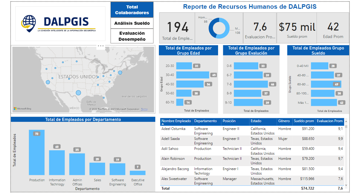

Dashboard with Power Bi

Dashboard with Power Bi

Dashboard with Power Bi

Dashboard with Power Bi

Dashboard with Power Bi

Dashboard with Power Bi
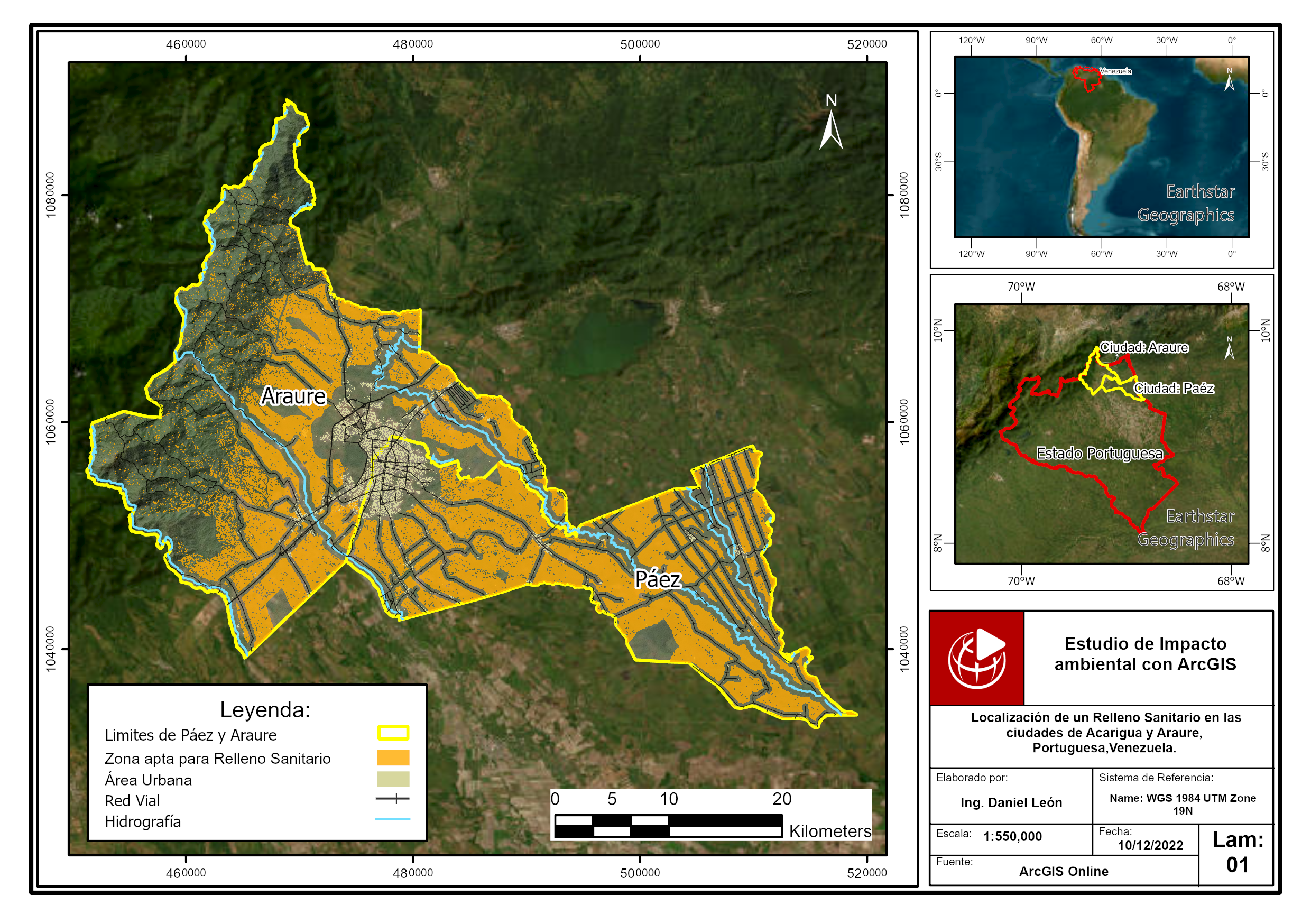

Location of a sanitary landfill through multicriteria analys

Location of a sanitary landfill through multicriteria analys
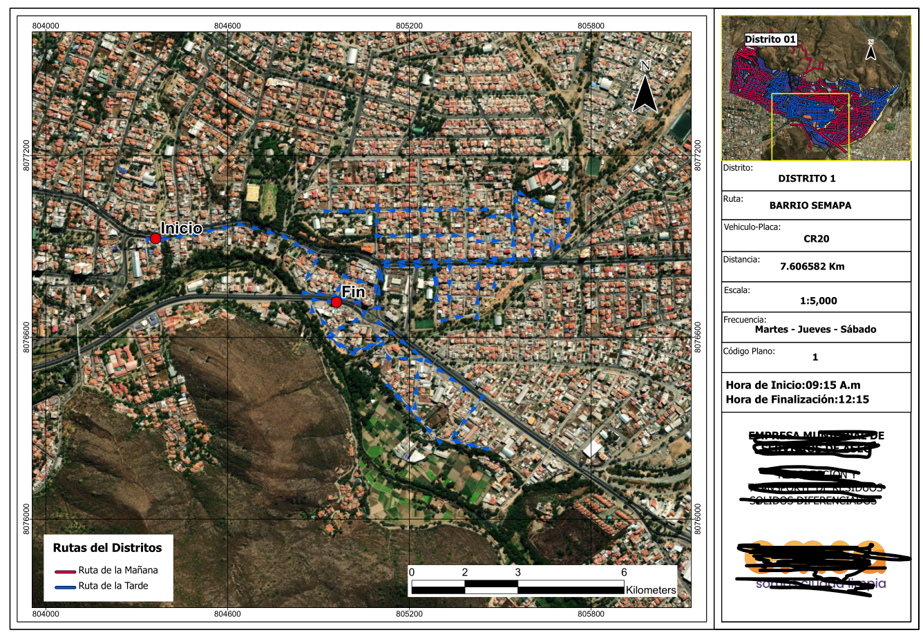

Series of maps to plan cleaning routes
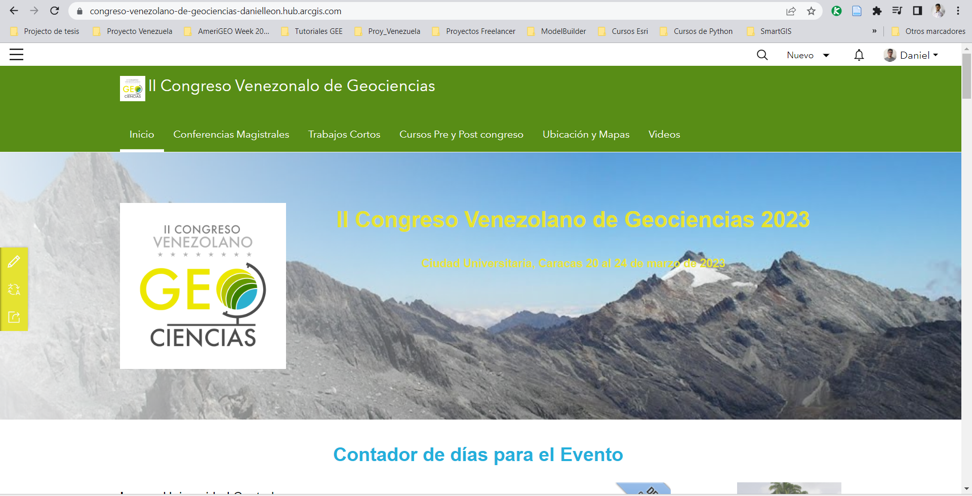

Web solution for events with ArcGIS

Web solution for events with ArcGIS

Web solution for events with ArcGIS

Web solution for events with ArcGIS

Site plan design for construction projects

Site plan design for construction projects

Site plan design for construction projects

Site plan design for construction projects

Site plan design for construction projects

Site plan design for construction projects
CAD data integration in ArcGIS Pro and 3D modeling
Dashboard with Power Bi
Dashboard with Power Bi
Dashboard with Power Bi
Dashboard with Power Bi
Dashboard with Power Bi
Dashboard with Power Bi
Location of a sanitary landfill through multicriteria analys
Location of a sanitary landfill through multicriteria analys
Series of maps to plan cleaning routes
Web solution for events with ArcGIS
Web solution for events with ArcGIS
Web solution for events with ArcGIS
Web solution for events with ArcGIS
Site plan design for construction projects
Site plan design for construction projects
Site plan design for construction projects
Site plan design for construction projects
Site plan design for construction projects
Site plan design for construction projects
Comentarios
Cambios guardados
Mostrando 1 - 5 de 9 reseñas
€100,00 EUR
Data Processing
Excel
Cartography & Maps
Geospatial
+1 más

•
$500,00 USD

•
€50,00 EUR
Data Processing
Excel
Cartography & Maps
Geospatial
+1 más
•
$200,00 USD
Excel
SPSS Statistics
ArcGIS
A
•
$200,00 USD
Data Processing
Excel
Cartography & Maps
Geospatial
+1 más
S

•
Experiencia
Applied Science Research Assistant
sept 2021 - Presente
Project Manager of Exposure and Seismic Vulnerability of Buildings Using Multispectral and UAV Imaging in Chosica, Peru.
Communications committee leader for AmeriGEO Week 2022.
Co-author of the "Manka Watikay" Project, where an analysis of the exposure of the Ollas Comunes to different types of threats was carried out.
Technical and logistical support with multidisciplinary representatives in international organizations and governments.
Educación
Technician in Topography
(2 años)
Civil Engineer
(6 años)
Contacta Daniel L. sobre tu trabajo
Inicia sesión para comentar cualquier detalle por chat.
Verificaciones
Principales habilidades
Explorar freelancers similares
Explorar galerías similares
¡Invitación enviada correctamente!
¡Gracias! Te hemos enviado un enlace para reclamar tu crédito gratuito.
Algo salió mal al enviar tu correo electrónico. Por favor, intenta de nuevo.
Falló el copiado al portapapeles. Intenta de nuevo después de ajustar tus permisos.
Copiado al portapapeles.
Cargando visualización previa
Permiso concedido para Geolocalización.
Tu sesión de acceso ha expirado y has sido desconectado. Por favor, inica sesión nuevamente.