

Ahora estás siguiendo a
Error al seguir a usuario.
Este usuario no permite que los usuarios lo sigan.
Ya estás siguiendo a este usuario.
Tu plan de membresía solo permite 0 seguimientos. Mejora tu membresía aquí.
Dejaste de seguir correctamente a
Error al dejar de seguir al usuario.
Has recomendado exitosamente a
Error al recomendar al usuario.
Algo salió mal. Por favor, actualiza la página e intenta de nuevo.
Email verificado correctamente.

mount pleasant,
australia
Aquí son las 10:13 p. m.
Se unió el septiembre 13, 2015
0 Recomendaciones
Duncan K.
@dakinnear88
0,0
0,0
0%
0%
mount pleasant,
australia
N/A
Trabajos finalizados
N/A
Dentro del presupuesto
N/A
A tiempo
N/A
Tasa de recontratación
GIS Specialist with background in geology
Contacta Duncan K. sobre tu trabajo
Inicia sesión para comentar cualquier detalle por chat.
Portafolio
Portafolio


Location Map


Predicted rainfall map of England & Wales


Crevasse strain plot on TerraSAR-X Radar image
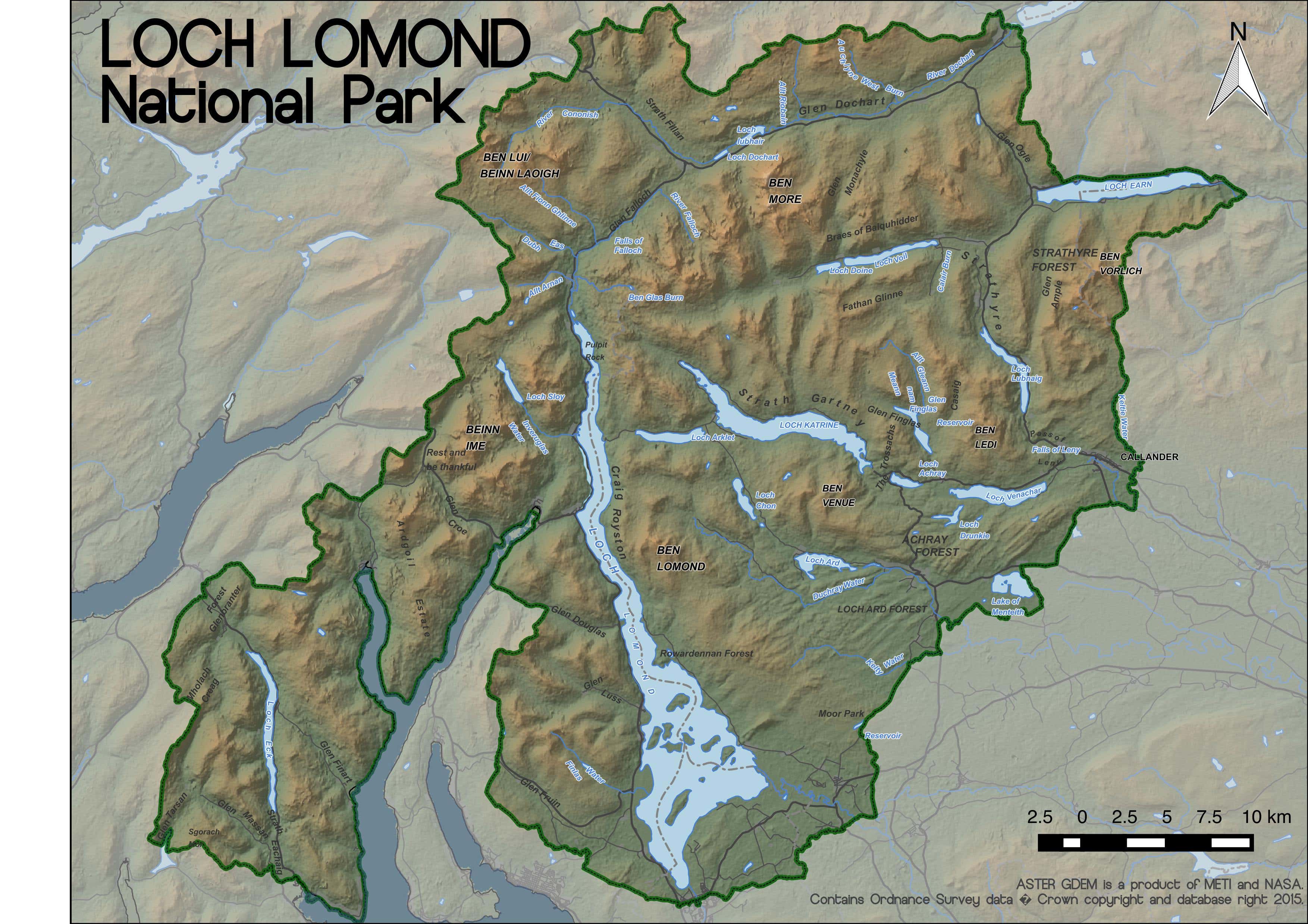

Loch Lomond National Park, Scotland


Hand-drawn geological map
Location Map
Predicted rainfall map of England & Wales
Crevasse strain plot on TerraSAR-X Radar image
Loch Lomond National Park, Scotland
Hand-drawn geological map
Comentarios
Cambios guardados
¡No hay comentarios para ver aquí!
Experiencia
GIS Consultant
jun 2018 - sept 2018 (3 meses, 1 día)
Processing wildlife survey data and producing report figures. Lake water/silt volume calculations using bathymetry data.
GIS Analyst
dic 2015 - nov 2017 (1 año, 11 meses)
Use of ArcGIS, QGIS, FME and bespoke Python scripts to tackle projects relating to water/wastewater networks and infrastructure across the UK. Creation of dynamic web maps/dashboards using MS Sharepoint and Javascript development to display real-time project information to a variety of stakeholders.
Teaching Assistant
sept 2014 - oct 2015 (1 año, 1 mes)
Tutor and lab assistant for undergraduate geology and geography students.
Educación
Master of Science (Geographical Information Science) - Distinction
(1 año)
BSc (Hons) - Earth Science - 2:1
(4 años)
Contacta Duncan K. sobre tu trabajo
Inicia sesión para comentar cualquier detalle por chat.
Verificaciones
Certificaciones
Principales habilidades
Explorar freelancers similares
Explorar galerías similares
¡Invitación enviada correctamente!
¡Gracias! Te hemos enviado un enlace para reclamar tu crédito gratuito.
Algo salió mal al enviar tu correo electrónico. Por favor, intenta de nuevo.
Falló el copiado al portapapeles. Intenta de nuevo después de ajustar tus permisos.
Copiado al portapapeles.
Cargando visualización previa
Permiso concedido para Geolocalización.
Tu sesión de acceso ha expirado y has sido desconectado. Por favor, inica sesión nuevamente.